Old Jail Lane Conservation Area: Difference between revisions
No edit summary |
No edit summary |
||
| Line 14: | Line 14: | ||
==About The Trail== | ==About The Trail== | ||
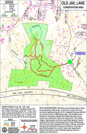
A hilly and rocky trail that takes you along the Cape Cod glacial moraine, this deceptively simple trail system connects in with [http://www.capecodcommission.org/pathways/ Cape Cod Pathways] Trails that will take you to trailheads at [http://www.capecod.mass.edu/ Cape Cod Community College] and [[Old Seabury Farm Conservation Area|Seabury Farm]]. The main trailhead has parking that only accommodates about five cars but the trails are only lightly used, mostly by local residents, so parking is rarely a problem. Depending on the season, the trails can be overgrown and aren’t always kept up. Overgrown grass can hide rocks and roots and expect to encounter some tree fall from time to time. Map kiosks are available at most major trail junctions but they are rudimentary and lack “You Are Here” reference points. Old fire and farm roads will take you out to Seabury Farm, a conservation area accessible from Route 6A just before [http://www.barnstable.k12.ma.us/BWB/index.html Barnstable West Elementary School], but many will take you to private property dead ends. Hunting is permitted in-season so check schedules before wandering too far from the main trails. | A hilly and rocky trail that takes you along the Cape Cod glacial moraine, this deceptively simple trail system connects in with [http://www.capecodcommission.org/pathways/ Cape Cod Pathways] Trails that will take you to trailheads at [http://www.capecod.mass.edu/ Cape Cod Community College] and [[Old Seabury Farm Conservation Area|Seabury Farm]]. The main trailhead has parking that only accommodates about five cars but the trails are only lightly used, mostly by local residents, so parking is rarely a problem. Depending on the season, the trails can be overgrown and aren’t always kept up. Overgrown grass can hide rocks and roots and expect to encounter some tree fall from time to time. Map kiosks are available at most major trail junctions but they are rudimentary and lack “You Are Here” reference points. Old fire and farm roads will take you out to [[Old Seabury Farm Conservation Area|Seabury Farm]], a conservation area accessible from Route 6A just before [http://www.barnstable.k12.ma.us/BWB/index.html Barnstable West Elementary School], but many will take you to private property dead ends. Hunting is permitted in-season so check schedules before wandering too far from the main trails. | ||
==Getting There== | ==Getting There== | ||
Revision as of 22:34, 24 October 2008
| Vital Statistics | |
|---|---|
| Town | Barnstable |
| Where | Trailhead is located about a half mile from the intersection of Old Jail Lane and Phinney’s Lane. |
| Distance | Various - 2.25 miles on outer loop |
| Surface | Grass, pine needles, roots and rocks |
| Ratings | |
| Overall | Moderate |
| Walking | Fair |
| Running | Fair - technical |
| Biking | Good - technical mountain biking |
| Hiking | Excellent |
About The Trail
A hilly and rocky trail that takes you along the Cape Cod glacial moraine, this deceptively simple trail system connects in with Cape Cod Pathways Trails that will take you to trailheads at Cape Cod Community College and Seabury Farm. The main trailhead has parking that only accommodates about five cars but the trails are only lightly used, mostly by local residents, so parking is rarely a problem. Depending on the season, the trails can be overgrown and aren’t always kept up. Overgrown grass can hide rocks and roots and expect to encounter some tree fall from time to time. Map kiosks are available at most major trail junctions but they are rudimentary and lack “You Are Here” reference points. Old fire and farm roads will take you out to Seabury Farm, a conservation area accessible from Route 6A just before Barnstable West Elementary School, but many will take you to private property dead ends. Hunting is permitted in-season so check schedules before wandering too far from the main trails.
Getting There
Take Route 6 to exit 6 and head south on Route 132. Bear left after the Hyannis Golf Club on to Hadaway Road. At the intersection with Phinney’s Lane, turn left and continue about 1/2 of a mile under the highway and take your next left on to Old Jail Lane. The entrance to the Conservation Area is about 1/2 a mile on the left. The parking area is shared with the driveway of a private residence so be sure to park in the designated areas and keep the driveway clear. To get to the trail, walk down the driveway to the green gate at the end and continue straight on to the main trail.
Maps
